Cyclone Gabrielle Aftermath 15th and 16th February 2023

https://www.google.com/url?sa=i&url=https%3A%2F%2Fbusinessdesk.co.nz%2Farticle%2Fclimate-change%2Fhawkes-bay-and-gisborne-lose-all-electricity-possibly-for-weeks&psig=AOvVaw3LLRdGdtiMbjUkoTWT2riz&ust=1677230748542000&source=images&cd=vfe&ved=0CBEQjhxqFwoTCJjT08Spq_0CFQAAAAAdAAAAABAE

Prayer in a Time of Disaster
Holy One, you are our comfort and strength in sudden disasters, crises, or chaos. Surround us now with your grace and peace through storm, earthquake, fire, or flood. With your Spirit, lift those who have fallen, and sustain those who work to rescue or rebuild. Fill us with the hope of your new creation through Jesus Christ, our rock and redeemer.

A Prayer for Rescue, Recovery and Relief workers
God, our help and hope when the waters rise, you bring Israel safety through the sea. Sustain all those who seek to save others, so they may repair the ruined cities, raise the former devastations and be the restorers of streets to live in through Jesus Christ, our eternal saviour. Isaiah 58, 61

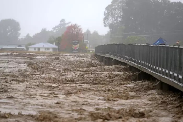
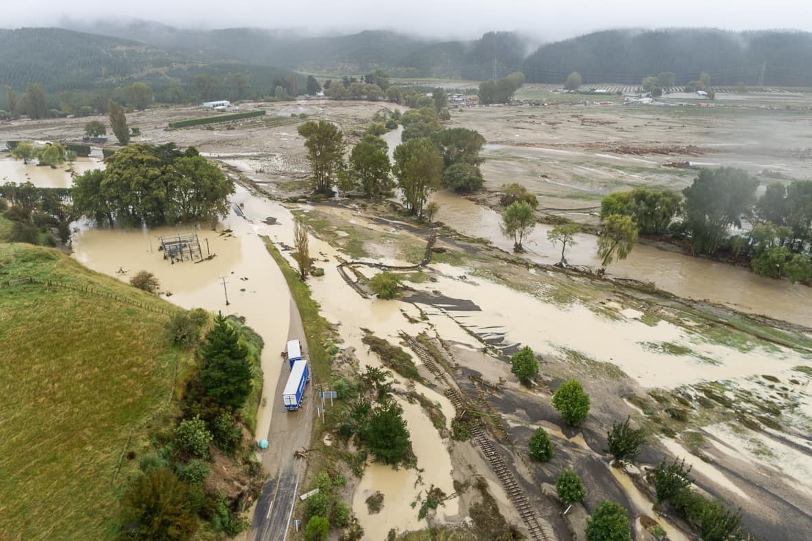
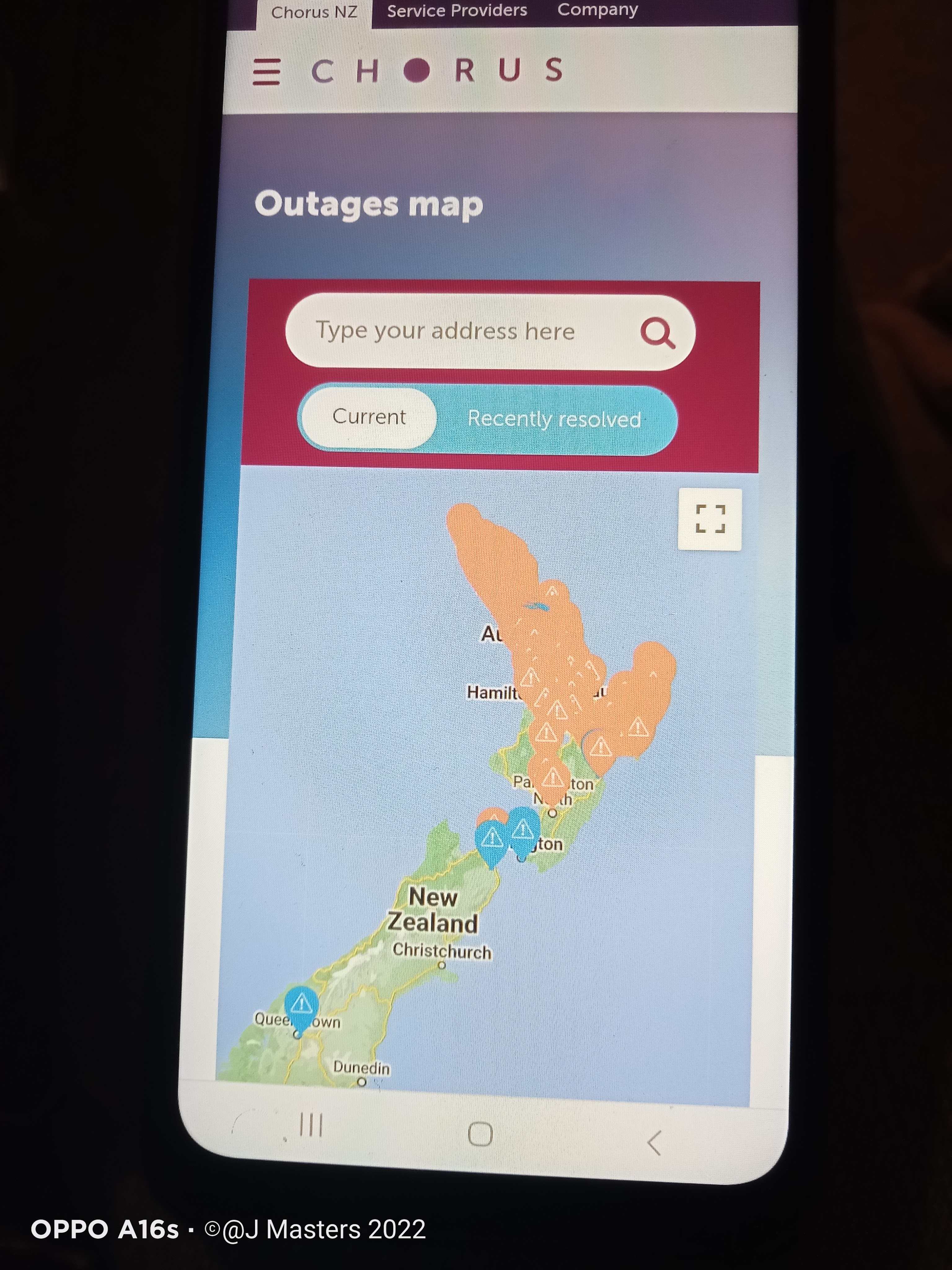
This year was the worst environmental disaster ever since Cyclone Bola hit Hawke’s Bay and the Gisborne/East Cape region on the East Coast of the North Island on March 7th 1988. The cyclone brought powerful, brute, and high winds that lashed out and slammed in every North Island region. Coromandel-Thames and Hawkes’ Bay-Gisborne were the only areas more severely affected than Greater Auckland.

Hawkes’ Bay region and Gisborne are different from Coromandel-Thames and Greater Auckland. In Hawkes’ Bay, the area is a low flat vast land toward the coast; several rivers run out to the ocean and contain many agriculture regions, orchards, wineries and Māori native plants and parks as in the Horticulture region. Many people in Hawkes’ Bay-Gisborne were unexpectedly unaware of the flash flooding, torrent flood rivers, riverbanks burst open and other issues overnight.

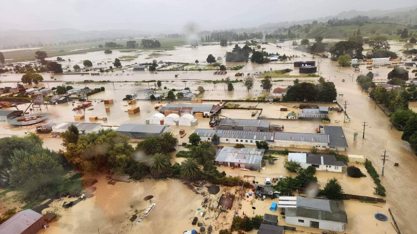
Thousands and thousands of residents and visitors were stranded for hours and hours until the rescue team came. Many residents were saved from flooding, and their emotional runs were severe such as shock, disbelief, grave concern for their loved ones, frustration and anxiety about their future. The residents have been completely cut off from outside the regions, with no telecommunication and no power for twenty-seven hours and more. The rescue teams and an emergency team located five people, including a child (two years old) who died overnight.

Many Hawkes’ Bay-Gisborne residents were caught off guard by the possibility that the flooding would be above the average level of the danger warning or thinking they would be okay. They were wrong and received unexpected preparation for the worst disaster in their lives again.

February 17th – Seven people died, including the second fireman who survived and was admitted to the hospital but passed away overnight.
On February 22nd, eleven people died (two firefighters in Muriwai and five people, including a young child in Hawke’s Bay-Gisborne.)

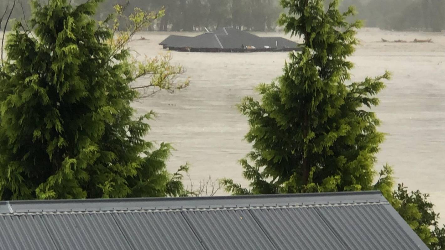
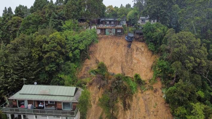
The worst floodings were in Esk Valley and Puketapu, with more than four metres of slit and mud flooding the valley, houses, and farmlands. The Waipawa River was the closest.

Why is this area received the worst?
Eskdale and Esk Valley should have been listed in the record for the Hazard map by Hawke’s Bay District Council. “Hawke’s Bay Regional Council confirmed it never issued a valley-wide advance evacuation notice, instead choosing to warn only those it deemed to be at specific risk. Stuff has also confirmed that the regional council never developed specific flood hazard maps for the valley, despite a recommendation to do so following a 2018 flood.” https://www.stuff.co.nz/national/300810300/cyclone-gabrielle-was-the-catastrophe-at-esk-valley-avoidable

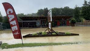
Eskdale Valley photos

https://en.wikipedia.org/wiki/Eskdale,_New_Zealand

https://www.stuff.co.nz/business/farming/131219988/esk-valley-vineyards-completely-flooded-and-facing-long-recovery

https://www.google.com/url?sa=i&url=https%3A%2F%2Fwww.nzherald.co.nz%2Fnz%2Fcyclone-gabrielle-mass-evacuations-in-hawkes-bay-dozens-rescued-some-still-trapped-by-floodwaters%2FT6SKCBU6E5CVBBOL7QD2GD6534%2F&psig=AOvVaw0ODS_xeFT-0KpysZwMvzQJ&ust=1677231523664000&source=images&cd=vfe&ved=0CBEQjhxqFwoTCOjGmLasq_0CFQAAAAAdAAAAABB2

https://gis.hbrc.govt.nz/hazards/

https://www.newsroom.co.nz/omahu-marae-and-settlement-near-hastings-flooded


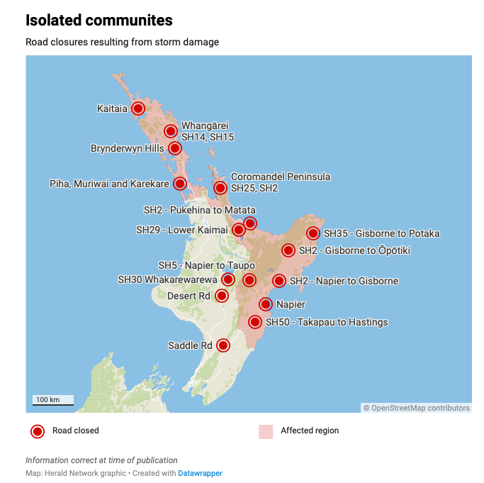
Have a look at the map before and after during Cyclone Gabrielle. Link https://www.nzherald.co.nz/nz/cyclone-gabrielle-floods-first-satellite-images-shows-extent-of-hawkes-bay-flooding/TX5QMIEM2JBRTKSH5PKTTECTSE/

https://www.nzherald.co.nz/hawkes-bay-today/news/cyclone-gabrielle-family-with-10-day-old-baby-rescued-by-helicopter-after-landslides-isolate-home/3LWHL3P3ZRE6XLBXPEDAIBXKXU/

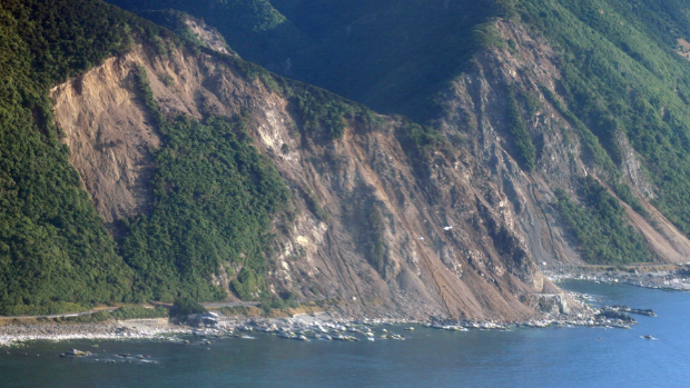
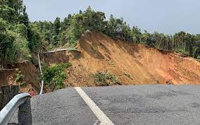
Here is the news from Port Waikato – badly affected by erosion for many years, Cyclone Gabrielle bought the worst for this local Port Waikato people.
Link: https://www.stuff.co.nz/waikato-times/news/300812203/recovery-for-cyclone-damaged-north-waikato-town-will-be-long-road

On March 7th 1988, Tropical Cyclone Bola lasted three days of torrential rains, which was the most damaging in this region. This month Cyclone Gabrielle brought the worst of all to this region for the second time.

The previous Cyclone was Tropical Cyclone Gisele (Wahine storm) in 1968, and fifty-one people died. A cousin lost their lives on the Lyttleton-Wellington ferry Wahine on 9 and 10 April 1968 at Barrett Reef, Wellington. What caused this ferry to sink there? The Wahine went out of control and struck at Barrett Reef due to strong wind; unable to control the ferry steering, the build-up of water in the ship holds and capsized. The wind was 150 km per hour, recorded at the Wellington Airport.

Note that one family lost one daughter, and nearly a son later became disabled. This family came home from Christchurch after visiting their other son, who is Deaf.
Link here: https://www.nzherald.co.nz/manawatu-guardian/news/horowhenua-woman-relives-wahine-ferry-tragedy-every-day/EFLUIWEZUQSYQUQ62XSKMSEAXI/

https://figure.nz/chart/Bp5atC12oR9uoJhC-ObNz5i7aIRIzwerC


https://www.stuff.co.nz/pou-tiaki/131090636/tmaki-makaurau-flood-response-put-disabled-at-risk-advocate-says

Update: February 22nd 2023

An interesting article from the New Zealand Herald: the Australian Emergency team arrived at Hawke’s Bay and other nearby regions and found our flooding differed from their Queensland flooding. What was the difference between here and in Queensland? It is the slit and mud here; where else in Queensland is just water.
Link here – https://www.nzherald.co.nz/hawkes-bay-today/news/cyclone-gabrielle-anzac-response-in-hawkes-bay-as-australian-firefighters-join-search-effort/YJSF4O5CU5BZREZBWMMWLVQKZ4/

What can we learn more to prepare and do something better for the next disaster next time?

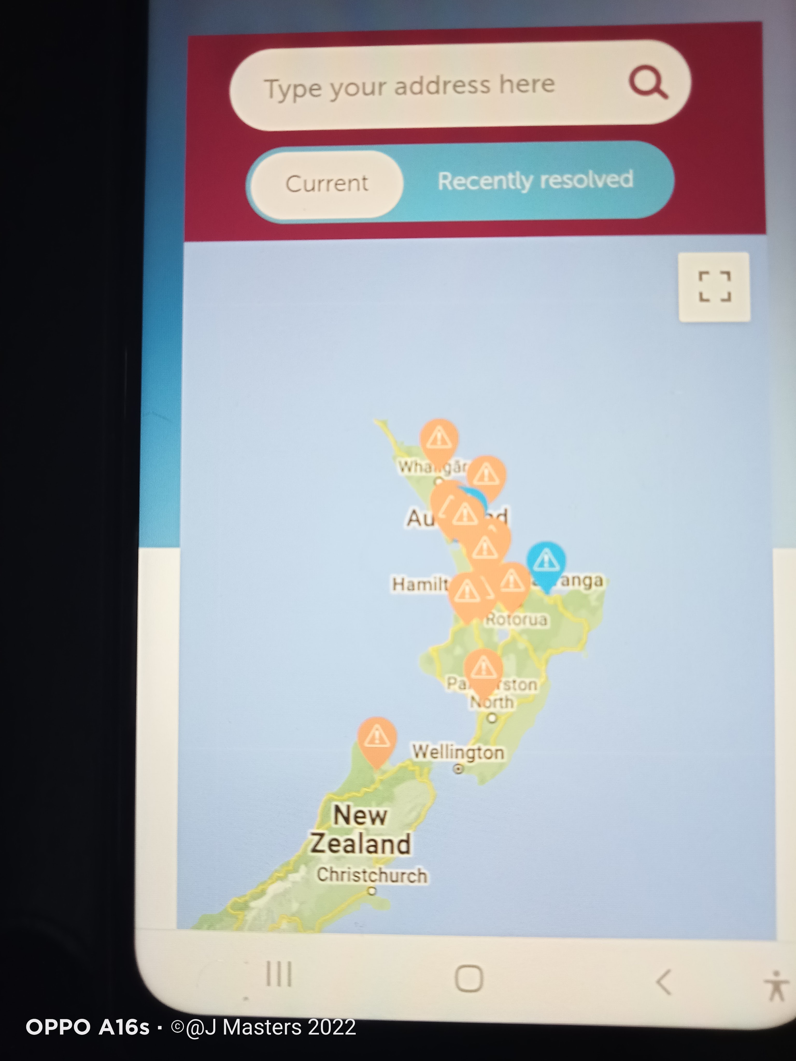
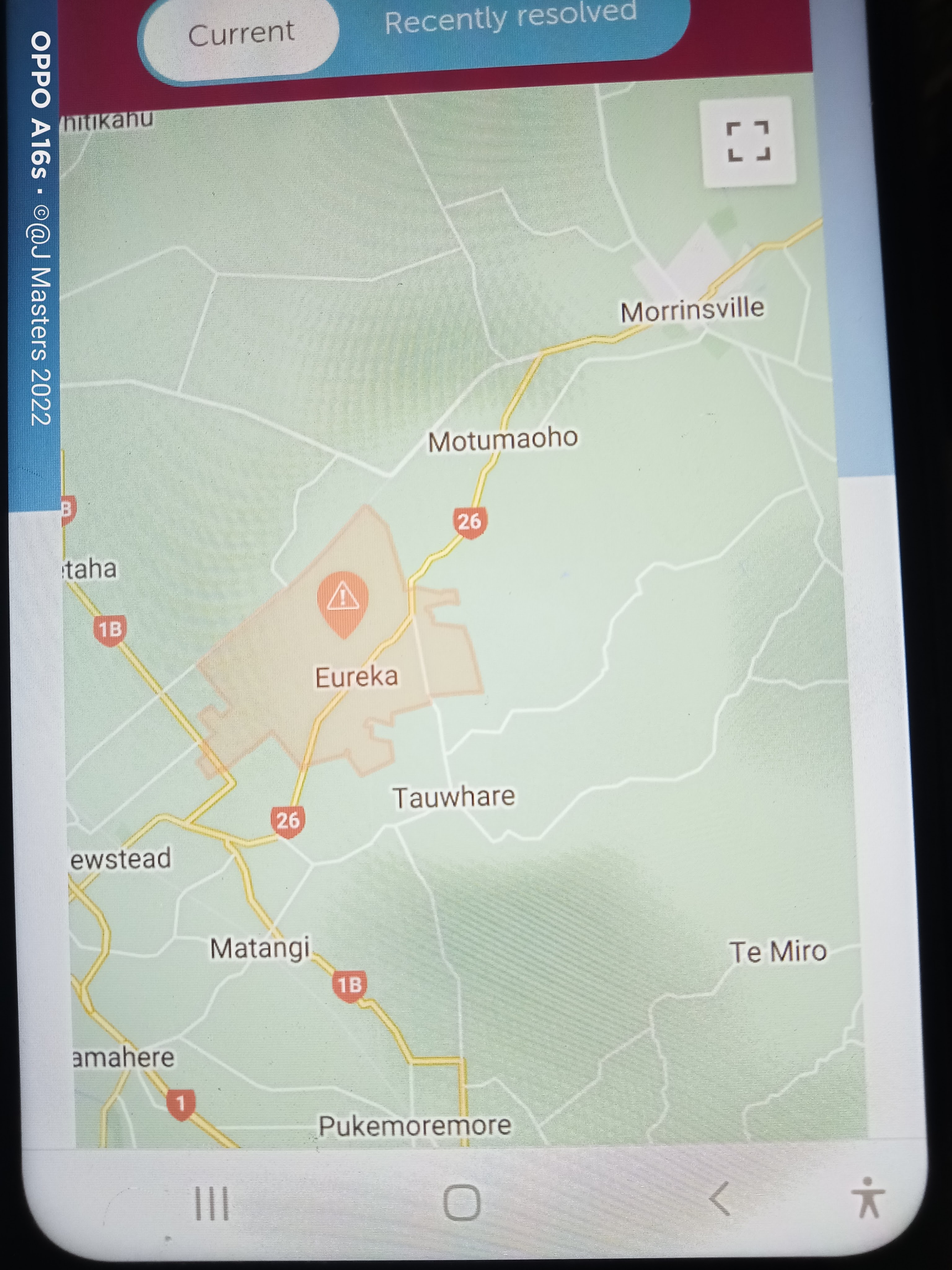
Several years ago, Hamilton District Council and team researched the city with a possible flood area. They listed areas where they may receive flood hazard areas for anyone wishing to build a house or to know how to prepare for their safety. There is a map display of the flood hazard area and a link. Hamilton City – https://maps.hamilton.govt.nz/floodviewer/

For the Waikato area – we are okay along with our neighbours. https://koordinates.com/from/data.waikatodistrict.govt.nz/data/?geotag=global%2Foceania%2Fnew-zealand%2Fwaikato%2Fwaikato-district

More to come..

Update on copper broadband and no internet connection for nearly a week (February 8th 2023) and Cyclone Gabrielle

https://www.rnz.co.nz/news/national/483498/saturated-coromandel-braces-for-more-rain

There has been no change since my last contact with Sparks via Chorus, and today there has been a wide outage in the Northland and Auckland due to Cyclone Gabrielle yesterday and today. 

Yesterday (February 12th 2023), across New Zealand, we received a weather alert warning about Cyclone Gabrielle coming toward New Zealand starting last night to Wednesday, February 15th. We live in Eureka, Waikato, and we do not get or received severe wild weather here over the years, only high winds. 

The main problem is the communication line to everyone I work with, support and assist around Waikato, Coromandel-Thames, and other parts of the North Island. The people I support/work with them are disabled, D/deaf and D/deaf with disabilities and Government agencies staff. It is difficult to check, and video chat with them over mobile data of 20Gb. Faxes to Deaf seniors are another problem because I use copper broadband ADSL line from home. The fibre line is no help and no match technology for any fax communication to the senior people who hate or refuse to accept new technology such as mobile and internet. 

Monday, February 13th – We still have no landline and internet connection until possibly Thursday, February 16th, instead of today. Another disappointing outcome. My partner was annoyed because he wanted to google something from his iPad, which was not working today. Then my partner was told by his boss to take another day off tomorrow due to heavy flooding in the construction area. I went over to check with one of the D/deaf persons for her well-being in Hamilton City, and I borrowed her WIFI while I was at her rental home because of the zoom meeting with the Government agencies for nearly two hours. 

February 14th 2023, our copper line/broadband line is still down, but our mobiles do not work very well because the telecommunication signal lagged and is very slow to download. Another disappointing outcome. We survived the storm – heavy high winds lashed out trees, branches, roofs, and power line overnight. We did have a small power cut before 4 am until I woke up when my partner said, ‘Looked out in the field’. Oh! The fig tree blew down, and the young avocado tree bent slightly but saved. The other pressing matter was to inspect our property to see if there was any damage. Just a few to name, a black wattle hardwood tree, a dahlia tree, a fig tree and a young pittosporum tree. 

Cyclone Gabrielle weather in New Zealand – 2023 February

It had been a strange summer season for us here because it is not an entire summer season for a long time. Last month we had several wild wet kinds of weather on the North Island, and it was the first cyclone – Hale. The destructive effect of the environment area is Coromandel-Thames than Greater Auckland. The difference between these regional areas is Coastal-rural and city. Coromandel-Thames regional is the most significant coastal rural with narrow roads and no other routes through the heavy bush area. Greater Auckland is the largest population with poor infrastructure – roads, building on the hilltops, buildings close to each other’s, and old underground water/sewage pipes. Along the coastal beaches, for example, Browns Bay, Mercury Bay or Tamaki Drive, there are multiple erosions by salt wind and ‘king waves or tidal waves wash out many sand banks. 

https://www.google.com/url?sa=i&url=https%3A%2F%2Fwww.stuff.co.nz%2Fnational%2F300795203%2Fslip-that-trapped-west-auckland-residents-sounded-like-an-earthquake&psig=AOvVaw3oQy-2lv3WbvQTK5ziRi8_&ust=1676503168113000&source=images&cd=vfe&ved=0CBEQjhxqFwoTCIDkmYiTlv0CFQAAAAAdAAAAABAE

In Coromandel-Thames regional, the main road, State highway 25a, closed due to continuous landslips of more than 100 metres and unable to repair or replace the road. The Geonet teams are working on planning and checking the land depth, soil types and many other issues with this road. Who knows how much it will cost them to replace this highway road? How long will this road be repaired? Most people will say about $2 billion or more.

Kaikoura in the South Island was severely affected by the earthquake/landslides and was one only central state Highway Road from Picton to Christchurch. The cost of repairing and scrapping part of the hill slope was $1.25 billion along the 60km between Clarence and Oaro in 2016. The repair job took two years instead of ten years. 

https://blogs.agu.org/landslideblog/2017/06/23/kaikoura-earthquake-landslides-2/

Coromandel-Thames State Highway 25a (North Island) is different to Kaikōura State Highway 1 (South Island) because Kaikōura is a coastal road which exposure to the coast and beach, not in the bush region like in the Coromandel-Thames (Hauraki regional).

Dubious is the people of Coromandel-Thames in their mind over State Highway 25a and how can they travel more quickly than going a long way round trip! I have been there several times, especially Flaxmill Bay and the road from Kopu to Flaxmill Bay or Whitianga. This road is a lovely winding route, and to admire the stunning ocean view over the mountain climbs and through many low bank farmlands on both sides of the road. I am not a fan of the longest winding road all the way because anyone must drive carefully on the curve bend, a narrow road with one hillside and the other side is a long drop down. But the best is the viewing toward Motuhoa/Shoe Island, WMW Slipper Island (Whakahau), and the Pacific Ocean. This region is a Coromandel Forest Park. 

February 14th, 2023, the worst fear came true, and the whole region of Coromandel-Thames, including the route to Whangamata, were wholly cut off with roads collapsed, heavy flooding over farmlands, landslips, coastal slips, power line down and, of course, communication line down. Isolated, they started cleaning up, repairing jobs, and wishing outsiders like Aucklanders and Waikato people to revisit Coromandel-Thames for their financial needs.

February 15th, 2023, the sun came out in the early hours of this morning, bought us delight in Eureka. I received a couple of text messages from the people, and their statements were, “did Coromandel-Thames suffer six times through bad storms?” My reply was, ‘Yes, and more regularly than in Greater Auckland and other parts of New Zealand.’ I watched the Breakfast News this morning, and the Prime Minister – Rt Hon. Chris Hipkins and his team are travelling to Coromandel-Thames to inspect and review the disaster region today.   

The downside is the poignant news from the Muriwai region near Greater Auckland about the missing firefighter that happened overnight on February 13th at midnight. Here is the updated news today, they found the body. 

https://www.rnz.co.nz/news/national/484262/muriwai-slip-body-found-in-search-for-trapped-firefighter

Where is the Muriwai region? A map of the Muriwai is listed here. https://en.wikipedia.org/wiki/Muriwai#/map/0

Again Muriwai Beach and region is a coastal community, different from the Coromandel-Thames region. 

Here is the link from across the North Island and you can view this. https://www.stuff.co.nz/national/weather-news/300806341/in-pictures-cyclone-gabrielle-cuts-path-of-destruction

Something dropped dead during the zoom meeting!

Wednesday 8th of February 2023

What is the heck going on in the middle of the zoom meeting??

I began to investigate our landline (copper line) and internet connection. I unplugged, retested and turned off the router, then turn back on. Nothing was back to resume at all around 1045am. 

Oh, bother, I will send the messages via messenger from my mobile because of the mobile data. Mm, not so helpful because of the exact instructions I must follow for testing. Blah blah, there have been outages across the North Island and the top part of the South Island. Oh, by looking at the Chorus outage app on my mobile. Crikey! I got a response from my partner and the staff – Spark saying they are working on it as soon as possible. One team sympathised with me. 

Time ticking away, time ticking away to evening 9 pm, and nothing resumed or restored the line. We wondered if it would be a very long time because we have been there before along with our local neighbours for five days – yep, five days was a very long time, and my emails and messages kept piling up. At least I popped into my work office in the city of Hamilton twice a week. My partner wanted to look up google search, read Waikato Times/NZ Herald and watch YouTube in the evening due to boring television programmes every evening. I tried to read newspapers, do online jigsaw puzzles and catch up on social media.

There was a pressing, urgent email I need to send out as soon as I wish for today, but hopefully tomorrow, I will be in another meeting, and I will send it off quickly as I can first thing in the morning. First, I would need to do the grocery for a deaf older man because his request was an ice cream on his grocery list. I could not fax him today because he does not have internet or mobile. After all, he hates it, wasting money, and his age is 91. His family does not have a fax machine, and they live out of the city, but the other family members are busy working, and one family member is in the hospital for surgery. It was impossible and challenging to access communication when the line was down. 

Thursday, 9th of February 2023

We woke up at 5 am as my partner goes to work by 6 am from Monday to Friday. I turned on the router while my partner picked up the handset phone – disappointed result: red light on the router and the sound of the landline tone dead. Oh, bother, and we knew we had more than two days in a row. My partner left for work, and I headed back to sleep for another hour before a full-day meeting with the EGL Waikato Leadership in Hamilton. I took my laptop instead of my Ipad and headed out for the discussion around 850am. Several quick check emails, read Waikato Times and NZ Herald through break times at Trust Waikato, Hamilton. I headed home instead of doing the grocery for one Deaf senior until tomorrow as it was 445pm. Finally got home at 515pm, let our three dogs out for fresh air and exercise, and ran as I switched on the router. Darn, there goes the red light again, and it was not good enough for our local Eureka community. My partner got home later and asked me for any good news – I replied no. Another day and night until I rechecked the outage by Chorus and discovered our landline, including our local neighbours, would resume around Saturday 11th. Yep, SATURDAY, as I told my partner, his reply was bloody hell.

Tomorrow I will be heading back to the city of Hamilton as I have two jobs as a support worker and work in my office at the Social Service, then to pick up my partner as he leaves his truck at the depot for the maintenance job. Another long day for me tomorrow.   

Friday 10th February

I woke up in the morning usual and there is no change. We, Eureka local people still been affected by the outage for three days in a row. Now I am in my office in Hamilton City and catching up on emails, printing off materials and cleaning up unwanted emails from my inbox. Our bill was paid this morning. The director of my workplace was affected too and she learnt a bit more detail about why the outage happened across North Island. It was something to do with upgrading copper broadband and fibre lines.

Many D/deaf people and D/deaf with disabilities love to communicate through social media such as video chat, zoom, and emails. Many unique technologies today than in the old days make our life better. Despite Broadband’s high cost, the fibre line shot up in the sky as three-quarters of D/deaf people could not afford to pay the line while one-quarter could pay the line because they work like me. There are no cheaper costs for Broadband with a good speed, and I know there is one called Skinny Broadband. I researched this company through Lockdown for the D/deaf people I support and obtained three modems from Skinny for them to stay in touch with their families through Lockdown. Many senior D/deaf people and D/deaf people with disabilities preferred to use fax machines in the past, and only less than one-quarter of them still use fax machines which I kept for four-five D/deaf with disabilities seniors from home. We cannot hear a voice over the telephone and mobile for many years.

Telecommunication companies and Chorus needs to think about people living in a rural area like us who run businesses in the tiny township. D/deaf people and D/deaf with disabilities need to reach out and stay in touch through communication while the line is up and running smoothly, NOT DOWN and struck down without contact or minimal promise of mobile data to top-up. We know a bill is due today (Wednesday 8th), but we are not paying until the online is up and running. Because I don’t have time to pop in Spark business after 430pm in Hamilton, it will take me to drive home 15 minutes to 20 minutes from the city of Hamilton tomorrow. I do not use online payment from my mobile because it is not ideal and safe. What senior people live in the rural countryside or retirement villages? Family and friends who have been isolated away from another area during a natural disaster like flooding in Thames-Coromandel cannot use Broadband and landline or without landline/broadband.     

There must be another way of resolving this problem now and in the future. At the end of this incident, we do not have any reason why there were massive outages again. Last time, our local community went without landline/broadband for five days until we learnt the small, transformed line station caught fire in our local area. They (Telecommunication) and Chorus did not let us know why we received no apology in the first place. We continue to pay the bill in full instead of minus five days charge cost.   

The strange last week was happening in the North Island, New Zealand. 

It is something you have not prepared for the worst disaster. 

https://www.rnz.co.nz/news/national/483557/scale-of-damage-to-sh25a-a-revelation-coromandel-mayor

The first time we ever have wild, shocking wet and heavy rainfall on the North Island since Cyclone Hale hit four weeks ago. The date was January 27th, and heavy rain in Auckland and Coromandel was very soggy downpours. It was unexpecting flooding up to two point five metres high in the Greater Auckland city of Mount Eden, Henderson, North Shore and several neighbours of suburbs. The Mayor of Auckland issued the State of Emergency and declared it through the media late evening. The people of Greater Auckland were angry, bittered and disappointed at the Mayor and Emergency Teams.  

Then we have the worst hit of many landslips around the Thames-Coromandel area, and many people, including those with disabilities, are isolated and cut off from the outside regions. There is nobody’s fault if you learn about natural disasters and be prepared for any natural disasters now or in the future. 

They (landslips and flooding) were followed by the Waimoto and Raglan areas this week. The Waitmoto Mayor declared the State of Emergency last Saturday, January 28th and ended the previous Monday, January 30th. Raglan will foresee cutting off and reducing the main routes between Hamilton to/from Raglan. 

February 3rd 2023 – The mayor, A State of Emergency, was declared for Thames-Coromandel and nearby areas. https://www.stuff.co.nz/waikato-times/news/300799264/state-of-emergency-declared-in-thamescoromandel-in-wake-of-storm

The plan to rebuild roads around Thames-Coromandel look bleak and uncertain on how to build, where is the best option to rebuild a new state highway route 25a to Whitianga and other towns and of course, how much money can help by rebuilding the new roads, to assist businesses, homes along the coastal state highway route 25 to Coromandel from Thames via Tapu, Te Kouma. There are several small farm roads cut off from the state highway routes. 

February 4th is more bad news for the Raglan Local community today because State Highway 23 is closed. There are several other roads for detours but an extra travelling time – fifty-three minutes. 

State Highway 23 Raglan

https://www.nzherald.co.nz/nz/major-crack-and-slump-closes-state-highway-23-between-whatawhata-and-raglan/5ELNREZDA5EU3LRPAZ5QPDYBEM/

Contrast the difference between Greater Auckland and Thames-Coromandel is one is a city (Auckland), and the other is local rural/coastal regionals of townships. 

In the city, there are large disability sectors around Greater Auckland, and they gain funding and run businesses, support groups and training centres. Looking at Raglan, Waitmoto and Thames-Coromandel, they have a small cluster of disability sectors linked to Hamilton city/Waikato Health (Te Whatu Ora – Health New Zealand)/Māori Health Authority, unsuccessful in funding needs, not within the less number of support groups and offices. In rural/coastal regions where, people with disabilities, senior people and people with mental illness people will find enormous challenges obsolete and impossible to reach out to Hamilton City or Greater Auckland city.  

Have you thought about the difference between the city and rural/coastal regions where the disaster strikes and the people with disabilities living in the area? Will the people with disabilities and the local rural/coastal people get funding and types of equipment to replace damaged particular varieties of equipment, foods, supplies, medicine, their homes and businesses in a time frame or in a long delay of waiting? Perhaps not; only Greater Auckland will gain most of the helps. 

If you understood the history of Auckland and the lands many years ago, it was home to approximately 53 volcanoes, whereas Thames-Coromandel is not home to any. The active and dormant volcano is Rangitoto Island, not far from Auckland, and it can be seen from Cheltenham Beach. Yes, there is a 0.1% chance of eruption at any time of the year. 

Maungawhau (Mount Eden), meaning the mountain of the whau tree, is 196 metres high and the highest natural point in Auckland. 

There was one volcano, and it is Pukekawa (Auckland Domain), which erupted over 100,000 years ago. Pukekawa is one of Auckland’s oldest volcanoes – and one of the most popular.

Most noticeably, Granular and Oxidic soils are limited to the warmer Northland and South Auckland regions. Allophonic and Pumice soils derived from volcanic ash are concentrated in the central part of the island.

Looking at the Thames-Coromandel soil – 

The soils are mainly loams derived from volcanic ash, crumble easily and are free draining. They strongly retain phosphate and sulphate, so relatively large amounts of superphosphate fertiliser are needed.

https://docs.tcdc.govt.nz/store/default/1371917

https://hwe.niwa.co.nz/event/September-October_1878_South_Island_Flooding

https://nzhistory.govt.nz/page/great-flood-hits-south-island

https://hwe.niwa.co.nz/event/February_1958_New_Zealand_Flooding

https://kura.aucklandlibraries.govt.nz/digital/collection/photos/id/124258/rec/6

https://paperspast.natlib.govt.nz/periodicals/new-zealand-graphic/1911/07/05/31

coromandel flood 1883 –

1907 – 

1899 – Auckland flood (Freemans bay) 

https://paperspast.natlib.govt.nz/newspapers/TC18930812.2.14.6?end_date=31-12-1920&items_per_page=10&query=floods+in+auckland&snippet=true&start_date=01-01-1839. (Not clear the location in 1893)

https://kura.aucklandlibraries.govt.nz/digital/collection/indexcards/id/138425/rec/7. Eden Park, the great flood in 1907. 

Waikato – Pokaiwhenuia stream near Cambridge. 1895 https://kura.aucklandlibraries.govt.nz/digital/collection/photos/id/111743/rec/12

Looking at the Natural disasters in the past – Cyclones and floods

1846 Taupō landslide

On May 7th, a massive landslide on the shores of Lake Taupō overwhelmed the kāinga (Māori village) of Te Rapa, killing around 60 people, including Ngāti Tūwharetoa leader Mananui Te Heuheu Tūkino II. Find out more.

1863 Central Otago floods

Twenty-five gold miners lost their lives as flash floods raged along the Shotover River, northeast of Queenstown, on July 26th 1863. Find out more on Te Ara.