It is something you have not prepared for the worst disaster.
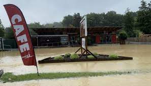
The first time we ever have wild, shocking wet and heavy rainfall on the North Island since Cyclone Hale hit four weeks ago. The date was January 27th, and heavy rain in Auckland and Coromandel was very soggy downpours. It was unexpecting flooding up to two point five metres high in the Greater Auckland city of Mount Eden, Henderson, North Shore and several neighbours of suburbs. The Mayor of Auckland issued the State of Emergency and declared it through the media late evening. The people of Greater Auckland were angry, bittered and disappointed at the Mayor and Emergency Teams.


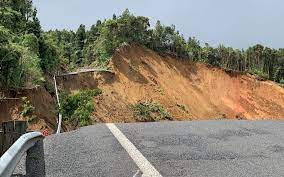
Then we have the worst hit of many landslips around the Thames-Coromandel area, and many people, including those with disabilities, are isolated and cut off from the outside regions. There is nobody’s fault if you learn about natural disasters and be prepared for any natural disasters now or in the future.
They (landslips and flooding) were followed by the Waimoto and Raglan areas this week. The Waitmoto Mayor declared the State of Emergency last Saturday, January 28th and ended the previous Monday, January 30th. Raglan will foresee cutting off and reducing the main routes between Hamilton to/from Raglan.
February 3rd 2023 – The mayor, A State of Emergency, was declared for Thames-Coromandel and nearby areas. https://www.stuff.co.nz/waikato-times/news/300799264/state-of-emergency-declared-in-thamescoromandel-in-wake-of-storm

The plan to rebuild roads around Thames-Coromandel look bleak and uncertain on how to build, where is the best option to rebuild a new state highway route 25a to Whitianga and other towns and of course, how much money can help by rebuilding the new roads, to assist businesses, homes along the coastal state highway route 25 to Coromandel from Thames via Tapu, Te Kouma. There are several small farm roads cut off from the state highway routes.
February 4th is more bad news for the Raglan Local community today because State Highway 23 is closed. There are several other roads for detours but an extra travelling time – fifty-three minutes.

Contrast the difference between Greater Auckland and Thames-Coromandel is one is a city (Auckland), and the other is local rural/coastal regionals of townships.
In the city, there are large disability sectors around Greater Auckland, and they gain funding and run businesses, support groups and training centres. Looking at Raglan, Waitmoto and Thames-Coromandel, they have a small cluster of disability sectors linked to Hamilton city/Waikato Health (Te Whatu Ora – Health New Zealand)/Māori Health Authority, unsuccessful in funding needs, not within the less number of support groups and offices. In rural/coastal regions where, people with disabilities, senior people and people with mental illness people will find enormous challenges obsolete and impossible to reach out to Hamilton City or Greater Auckland city.


Have you thought about the difference between the city and rural/coastal regions where the disaster strikes and the people with disabilities living in the area? Will the people with disabilities and the local rural/coastal people get funding and types of equipment to replace damaged particular varieties of equipment, foods, supplies, medicine, their homes and businesses in a time frame or in a long delay of waiting? Perhaps not; only Greater Auckland will gain most of the helps.
If you understood the history of Auckland and the lands many years ago, it was home to approximately 53 volcanoes, whereas Thames-Coromandel is not home to any. The active and dormant volcano is Rangitoto Island, not far from Auckland, and it can be seen from Cheltenham Beach. Yes, there is a 0.1% chance of eruption at any time of the year.

Maungawhau (Mount Eden), meaning the mountain of the whau tree, is 196 metres high and the highest natural point in Auckland.
There was one volcano, and it is Pukekawa (Auckland Domain), which erupted over 100,000 years ago. Pukekawa is one of Auckland’s oldest volcanoes – and one of the most popular.
Most noticeably, Granular and Oxidic soils are limited to the warmer Northland and South Auckland regions. Allophonic and Pumice soils derived from volcanic ash are concentrated in the central part of the island.
Looking at the Thames-Coromandel soil –
The soils are mainly loams derived from volcanic ash, crumble easily and are free draining. They strongly retain phosphate and sulphate, so relatively large amounts of superphosphate fertiliser are needed.
https://docs.tcdc.govt.nz/store/default/1371917
https://hwe.niwa.co.nz/event/September-October_1878_South_Island_Flooding
https://nzhistory.govt.nz/page/great-flood-hits-south-island
https://hwe.niwa.co.nz/event/February_1958_New_Zealand_Flooding
https://kura.aucklandlibraries.govt.nz/digital/collection/photos/id/124258/rec/6
https://paperspast.natlib.govt.nz/periodicals/new-zealand-graphic/1911/07/05/31
coromandel flood 1883 –
1907 –
1899 – Auckland flood (Freemans bay)
https://paperspast.natlib.govt.nz/newspapers/TC18930812.2.14.6?end_date=31-12-1920&items_per_page=10&query=floods+in+auckland&snippet=true&start_date=01-01-1839. (Not clear the location in 1893)
https://kura.aucklandlibraries.govt.nz/digital/collection/indexcards/id/138425/rec/7. Eden Park, the great flood in 1907.
Waikato – Pokaiwhenuia stream near Cambridge. 1895 https://kura.aucklandlibraries.govt.nz/digital/collection/photos/id/111743/rec/12
Looking at the Natural disasters in the past – Cyclones and floods
- Kopuawhara floods – Mahia Peninsula, 1938
- Cyclone Giselle – New Zealand-wide, 1968
- Southland floods – 1984
- Cyclone Bola – East Coast, North Island, 1988
1846 Taupō landslide
On May 7th, a massive landslide on the shores of Lake Taupō overwhelmed the kāinga (Māori village) of Te Rapa, killing around 60 people, including Ngāti Tūwharetoa leader Mananui Te Heuheu Tūkino II. Find out more.
1863 Central Otago floods
Twenty-five gold miners lost their lives as flash floods raged along the Shotover River, northeast of Queenstown, on July 26th 1863. Find out more on Te Ara.
